 |
DESTINATIONS: |
 |
Kamchatka: where the Earth bares its soul
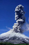
General Information about KamchatkaGeography Northern point – latitude 650 North - is the latitude of Arkhangelsk city. Southern point (the Lopatka cape) – latitude 50057’ North - is the latitude of Kiev city in the Ukraine. The coasts of Kamchatka are bounded by the Sea of Okhotsk in the west, the Bering Sea in the north-east and by the Pacific Ocean in the south-west. Deep Kurile-Kamchatkan gutter stretches along the east coastline. The landscape is mostly mountainous, almost parallel to each other two mountain ranges the Middle and the Eastern extend along the whole peninsula. There are 300 hot springs, 29 active and about 160 extinct volcanoes located in the territory of the peninsula. Lowlands are mainly in the north and the west of the peninsula. Western coast has a straight boarder line, flat landscape, eastern one is cut with half-peninsulas and bays, among them there is one of the most beautiful harbor the Avachinsky inlet. Climate Tourist season in Kamchatka lasts all the year round. The best time for visit is from middle July to the end of September. But the peninsula climate can make surprises for you: stormy wind, cold rain, morning light frosts, evening fogs. It’s well known that in Kamchatka there are no thunderstorms. The vicinity of Arctic, mountains, volcanoes, glaciers, cyclone activity, seas take part in forming of Kamchatkan climate. Coastal areas are characterized by moderate climate. The Sea of Okhotsk famous as “the world fridge” forms weather on the west coast. The climate of the east coast depends on cyclones, bringing warm and wet air from the Japanese and the Yellow seas. They provoke long lasting snowfalls, snowstorms and stormy winds with arising of temperature and precipitation. In the middle and northern parts of Kamchatka the climate is almost continental because on the lowland (The Central Kamchatkan Depression), which is defended from cyclones influence by the Middle and the Eastern Mountain Ridges, frosty, windless and almost unclouded weather prevails. The warmest months are July and August. In winter snow layer reaches 3 and even more meters in height. It lays in average for 222 days. Snow starts to melt in April, on the mountains this process lasts till August. The climate in the central part of the peninsula is continental with hot summers and severe winters. Short northern summer constantly breathes with coolness. Only in the Kamchatka River valley the temperature remains more than 100 C during 90 days. Sometimes in another regions temperature remaining above zero does not guarantee warmth. Light frosts in summer can spoil your vacation. Average temperatures in summer are not higher than +12 to +150 C in coast area. However there may be days with temperatures up to +25…+300 C. The absolute temperature maximum ( +350C) was registered in the Milkovsky district, the absolute minimum is –49-60 0 C in central and northern parts of the peninsula. Night temperatures along river valleys can go to +5…+80 C. The number of days with temperature over +200 C in summer: in coast area is 1-6, in the valley of Kamchatka river it is 35-55. In winter, temperatures
rarely go below –8…-100 C in coast area, although really dramatic
weather can occur in January, pushing the temperature down to –250
C. Population
Petropavlovsk-Kamchatsky Founded in 1740 by the famous navigator Vitus Bering, it is one of old cities of Russian Far East. Its population is about 200.000 inhabitants; most of them are fishermen, ship repairers, traders, geologists, students etc. See several schemes of Petropavlovsk-Kamchatsky on the maps page. |
Crater of the Gorely volcano with the lake in it |
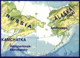 Geographical
location of the Kamchatka region is Far North-East of Russia The
area is 472,3 thousand km2. The territory includes the whole Kamchatka
peninsula and part of adjoining continent, the Komandorsky islands,
the Karaginsky island. The territory of Kamchatka includes the Koryaksky
Authonomous Region (305,5 thousand km2 ). England, Portugal, Belgium
and Luxemburg together can be placed on the territory of Kamchatka.
Geographical
location of the Kamchatka region is Far North-East of Russia The
area is 472,3 thousand km2. The territory includes the whole Kamchatka
peninsula and part of adjoining continent, the Komandorsky islands,
the Karaginsky island. The territory of Kamchatka includes the Koryaksky
Authonomous Region (305,5 thousand km2 ). England, Portugal, Belgium
and Luxemburg together can be placed on the territory of Kamchatka.
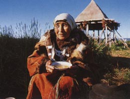 Population
of Kamchatka is not numerous and not even. The number of population
on the 1st January 2001 was 390 000. Most of the inhabitants settle
in the cities and towns, and in valley of the Avacha and the Kamchatka
rivers. Till 1986 population of the region increased due to arriving
of newcomers. Nowadays back migration lessens population. Average
density of population is low: less than 1 person per 1 km2 .
Population
of Kamchatka is not numerous and not even. The number of population
on the 1st January 2001 was 390 000. Most of the inhabitants settle
in the cities and towns, and in valley of the Avacha and the Kamchatka
rivers. Till 1986 population of the region increased due to arriving
of newcomers. Nowadays back migration lessens population. Average
density of population is low: less than 1 person per 1 km2 . 
Wild
Russia / Neizvedanny Mir Company
Saint Petersburg, Fontanka embankment, 59
+7 812 703-3215
+7 812 703-3216
+7 812 703-3249
Email: info@wildrussia.spb.ru